vrouwelijke projectleiders goed hebben gescoord (2 van de 5, namelijk Taylor en Carton)!
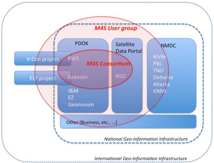
Maps4Society is an initiative in which the Maps4Society partners, Rijkswaterstaat, Kadaster, the Netherlands Space Office (NSO) and the Netherlands Geodetic Commission (NCG-KNAW) outline the research themes.
Universities are invited to submit dedicated research proposals in a tender.
The goal of the programme is to improve the existing national geo-information infrastructure (PDOK, NMDC and the national Satellite Data portal) via various innovations and align this with international developments, such as the EU FP7 project European Location Framework (ELF, started in March 2013).
Maps4Society documents (most recent first):
- Maps4Society News flash nr. 20, December 2014 (only Dutch version)
- Maps4Society News flash nr. 19, November 2014 (only Dutch version)
- Maps4Society persbericht (concept), 20 oktober 2014 (in Dutch)
- Aanpak Kennis, Communicatie & Utilisatie (concept), oktober 2014 (in Dutch)
- Maps4Society News flash nr. 18, September 2014 (only Dutch version)
- Maps4Society News flash nr. 17, April / May 2014 (only Dutch version)
- Maps4Society FAQ, mainly related to full proposals to be submitted before May 12 2014 (in Dutch)
- Maps4Society News flash nr. 16, February / March 2014 (only Dutch version)
- Maps4Society News flash nr. 15, January 2014 (only Dutch version)
- Maps4Society News flash nr. 14, December 2013 (Dutch version)
- Short minutes Matchmaking event (8 November 2013, in Dutch)
- Uitnodigingsbrief Matchmaking event (8 November 2013, Den Haag, in Dutch)
- Maps4Society Programme Plan, November 2013
- Maps4Science News flash nr. 13, November 2013 (only Dutch version)
- Maps4Science News flash nr. 12, September / October 2013 (Dutch version)
- Maps4Science News flash nr. 11, July 2013 (Dutch version)
- Maps4Science News flash nr. 10, June 2013 (Dutch version)
- Maps4Science News flash nr. 9, April 2013 (Dutch version)
- Report (concept) Utilisatiebijeenkomst Maps4Society, March 15, 2013 (in Dutch)
- Presentation Utilisatiebijeenkomst Maps4Society, March 15, 2013 (in Dutch)
- Participants Utilisatiebijeenkomst Maps4Society, March 15, 2013 (in Dutch)
Letters of support for Maps4Society were received from the following organizations:
- Alterra, Wageningen UR
- COMMIT, ICT Roadmap
- Data Archiving and Networked Services (DANS)
- Erasmus Universiteit Rotterdam
- Esri Nederland
- Fugro GeoServices B.V.
- GeoBusiness Nederland
- Geodan b.v.
- Geonovum
- Hansje Brinker BV
- HAS Hogeschool
- Netherlands Geomatics & Earth Observation B.V. (NEO)
- Nieuwland Geo-Information
- Nationaal Modellen- en Data Centrum (NMDC)
- Topsector Water
- Witteveen+Bos Raadgevende ingenieurs B.V.